Drone-Deployed Mesh Networks (2026): Emergency Communications, HAPS, Satellite Backhaul, and Disaster Response
Drone-deployed mesh networks combine UAVs, HAPS, and satellite backhaul to restore emergency communications after disasters.

Drone-Deployed Mesh Networks: Establishing Emergency Communication in Disaster Zones
1. Executive Summary
1.1 Purpose and Scope
This report examines the convergence of unmanned aerial systems (UAS), wireless mesh networking, and emergency communications. It analyzes how aerial platforms, including tethered drones, free-flying rotary-wing UAVs, fixed-wing platforms, lighter-than-air aerostats, and high-altitude platform stations (HAPS), can serve as rapidly deployable nodes in mesh and ad hoc networks following natural disasters, armed conflicts, and critical infrastructure failures. The analysis is intended for senior policy, defense, telecommunications, and institutional investment audiences. Where empirical evidence is limited or contested, the report flags this rather than smoothing over uncertainty.
1.2 Headline Findings
Available evidence suggests that aerial communications nodes have moved from experimental status to a documented, repeatedly used component of disaster response in the United States, Japan, and parts of the Caribbean, but that the most ambitious form factor, multi-day, free flying mesh swarms operating at scale in contested electromagnetic environments, remains largely a research-and-development proposition rather than a fielded capability [1][2][3]. Tethered platforms and aerostats have proven the most operationally mature for sustained communications coverage, while fixed-wing HAPS systems from AALTO (Airbus), Sceye, and SoftBank are approaching pre-commercial service in Japan and the United States but have not yet demonstrated multi-month-duration commercial connectivity at scale [4][5][6]. The Russia-Ukraine war has illustrated both the value and the strategic vulnerability of commercial satellite backhaul as a substitute or complement to aerial mesh nodes [7][8][9].
1.3 Strategic Implications
For governments and operators, the analysis points to three durable conclusions. First, drone deployed mesh networks are best understood as one tier in a layered resilience architecture that includes terrestrial public safety networks (FirstNet, ESN, SafeNet), satellite backhaul (LEO and GEO), and prepositioned ground deployables. Second, dual-use export controls (particularly the U.S. Federal Communications Commission's December 2025 expansion of its Covered List to include foreign-produced UAS and critical components) have materially reshaped the supply chain and procurement calculus for U.S. operators and allied agencies [10][11]. Third, market estimates for adjacent categories (drone communications, swarm mesh networking, HAPS) diverge substantially due to differences in scope and methodology and should not be relied upon individually for capital allocation decisions.
2. Contextual Background and Problem Definition
2.1 The Communications Failure Mode in Modern Disasters
Modern wireless communications infrastructure is highly capable but also brittle in the face of compound shocks. Hurricane Maria's 2017 landfall in Puerto Rico is the canonical reference event: U.S. Federal Communications Commission (FCC) reporting documented that 95.6 percent of cell sites were out of service shortly after landfall, with 48 of 78 municipios reporting 100 percent of cell sites offline [12][13]. The FCC's August 2018 review of the 2017 Atlantic hurricane season noted that wireless service in Puerto Rico was restored only gradually over a six-month period, and that 4.3 percent of Puerto Rican cell sites and 12 percent of U.S. Virgin Islands cell sites remained out of service six months after Maria [13]. The 2021 U.S. Government Accountability Office (GAO) review found that the FCC's disaster response role was insufficiently defined in Department of Homeland Security guidance and that the FCC had not publicly accounted for the activities of its Hurricane Recovery Task Force [14].
The 2023 Türkiye–Syria earthquakes produced a similar pattern. Reporting from Yıldız Technical University's drone communications research program states that approximately 30 percent of base stations in the affected region were rendered inoperable, leaving thousands of survivors unable to reach rescue services [15]. Available data implies that the absolute number of damaged sites was high in dense urban areas such as Antakya, but a comprehensive forensic accounting of telecommunications damage in southeast Türkiye and northwest Syria comparable to the FCC's Maria reporting is not, to the author's knowledge, publicly available. Damage estimates for the broader earthquake exceeded USD 148.8 billion in Türkiye and USD 9 billion in Syria [16].
2.2 The Operational Gap Drone-Deployed Mesh Networks Address
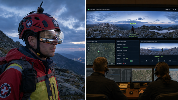
Conventional disaster recovery assets, such as cell on wheels (COWs), cells on light trucks (COLTs), satellite cell on light trucks (SatCOLTs), and portable generators, are constrained by road access, fuel logistics, and antenna height. Aerial platforms address three specific limitations: (i) line-of-sight to user equipment in topographically complex or rubble-strewn environments; (ii) coverage of areas inaccessible to ground vehicles within the first 24–72 hours; and (iii) longer aerial standoff distance from contaminated, flooded, or contested zones. AT&T's published characterization of its Flying COW indicates coverage of up to 40 square miles per platform under favorable conditions, with continuous tethered operation theoretically up to 16 days; later reporting expands the figure to as much as 240 square miles depending on terrain, foliage, and atmospheric conditions [1][17]. These figures are vendor estimates and have not, in publicly available data, been independently verified by an FCC, FAA, or third-party regulator
2.3 Definitions and Scope Boundaries
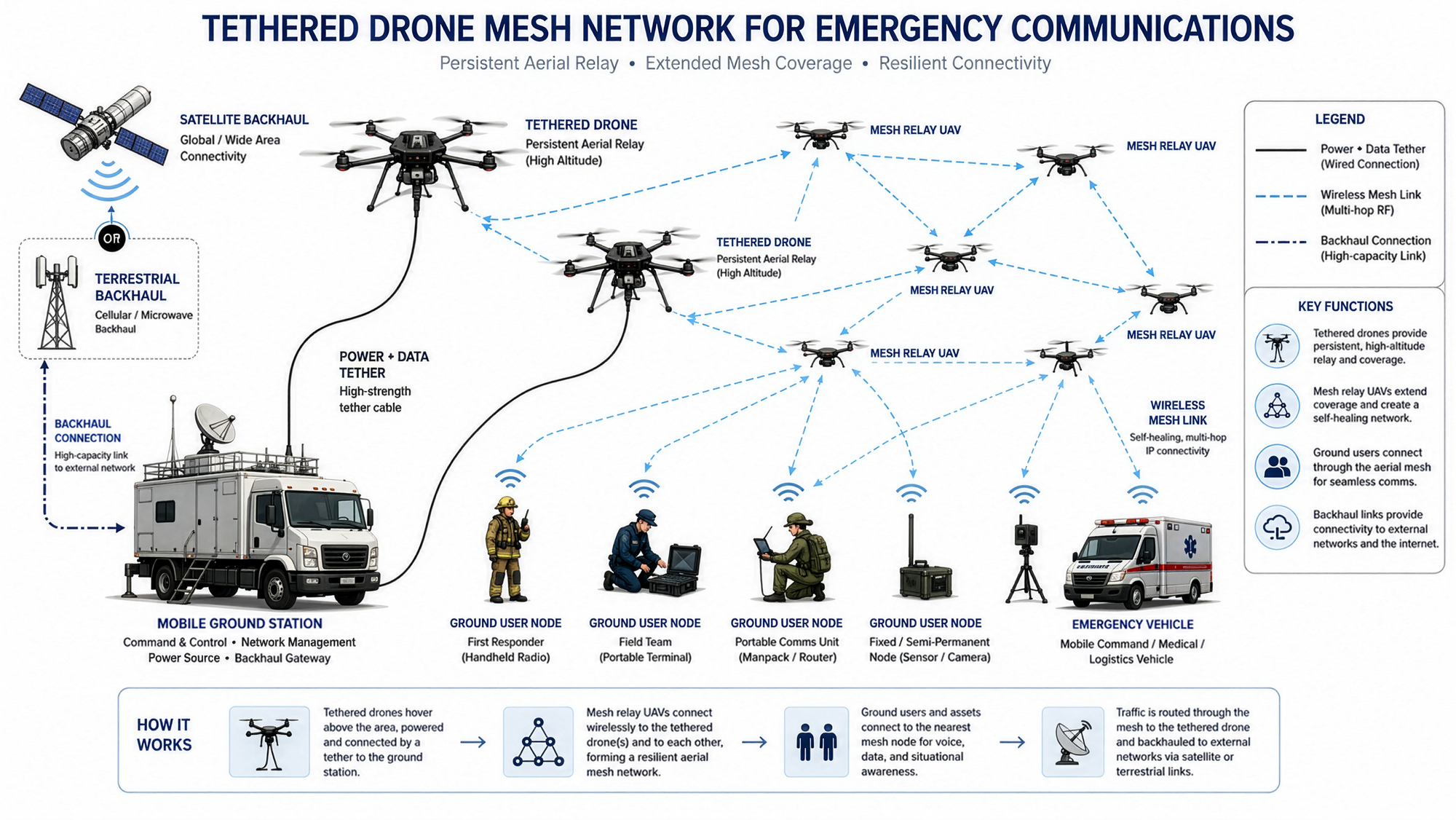
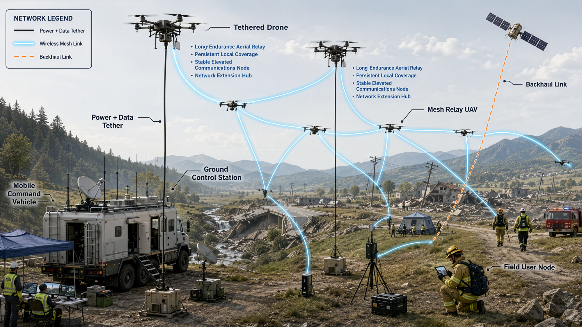
For purposes of this analysis, "drone-deployed mesh networks" refers to architectures in which one or more uncrewed aerial platforms function as nodes, base stations, relays, or both, within a self-organizing network using multi-hop routing to deliver voice, data, or push-to-talk services to ground users. The scope encompasses tethered rotary platforms, free-flying rotary and fixed-wing UAVs, lighter-than-air aerostats, and HAPS operating in the stratosphere between approximately 18 to 25 kilometers altitude. It does not include satellite-only architectures, although satellite backhaul to aerial nodes is treated as an integration question.
3. Technological Foundations and Operational Architectures
3.1 Aerial Platform Taxonomy and Tradeoffs
Each platform class trades off endurance, payload, weather tolerance, and link budget against deployment speed and operational footprint.
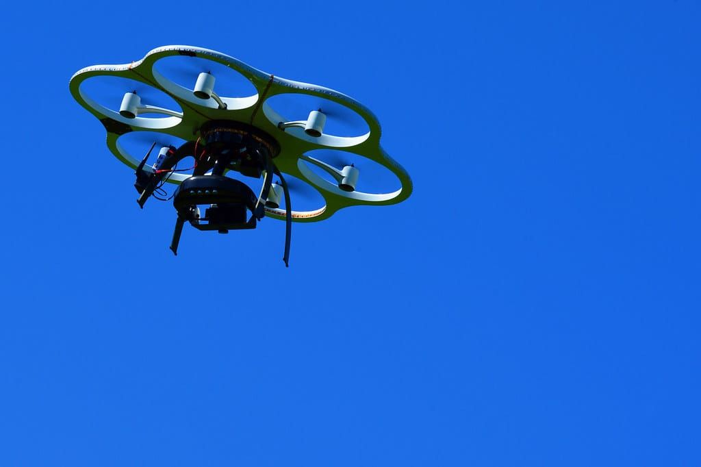
Tethered rotary platforms dominate near-term operational deployments. Power and, in fiber tethered variants, data are supplied through the tether, removing battery endurance as a binding constraint. AT&T's Flying COW is tethered, weighs up to 55 pounds with payload to operate under FAA Part 107, and reportedly receives approximately 5,000 watts at 450 volts through the tether [17]. Industry vendors including Hoverfly Technologies and Zenith Aerotech publish endurance figures exceeding 100 continuous hours under favorable conditions, with Zenith claiming a 108-hour continuous flight on its Quad 8 platform terminated only by lightning [18] [19]. The principal tradeoff is geographic immobility once tethered: the platform can move only a few tens of meters horizontally from the base station.
Free-flying rotary UAVs offer mobility and rapid repositioning but, in the absence of tethered power, are typically constrained to flight times of 30 to 40 minutes once communications payload mass is accounted for [20][21]. Peer-reviewed analyses comparing tethered and untethered UAV base stations conclude that untethered platforms can be repositioned to optimize coverage but require fleet rotation, charging logistics, and additional ground support to provide continuous service [21]. Free-flying platforms are therefore most useful for short duration missions, mesh relay roles in swarms, and applications where a tether is operationally infeasible.
Fixed-wing UAVs provide longer endurance than rotary platforms but require either continuous forward motion or specific orbit patterns and are less suitable for persistent coverage of fixed ground areas at low altitude. Their primary role in mesh architectures is as long-range relays or as platforms transitioning between communication posts and forward edges.
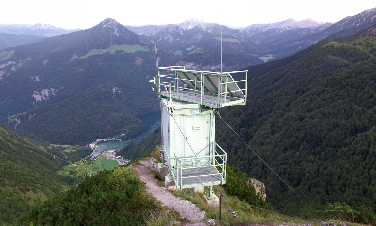
Lighter-than-air aerostats and blimps offer extended on-station time at higher altitudes than rotary platforms. AT&T's FirstNet One aerostat, a roughly 55-foot helium-filled platform, can operate up to approximately 1,000 to 1,500 feet, is fully operational in winds up to 50 miles per hour, can withstand winds up to 70 miles per hour, and can remain aloft for approximately two to three weeks before needing helium top-off [22][23][24]. FirstNet One had its first operational deployment following Hurricane Laura in September 2020 over Cameron Parish, Louisiana [22] [25]. The tradeoffs include slow setup (more than a day in some conditions, with inflation requiring sub-15 mph winds), slow recovery (a half day or more to retract), and limited mobility once deployed [22].
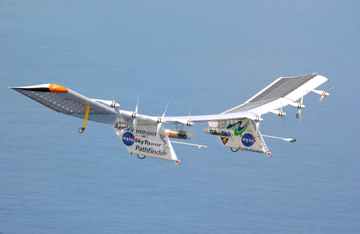
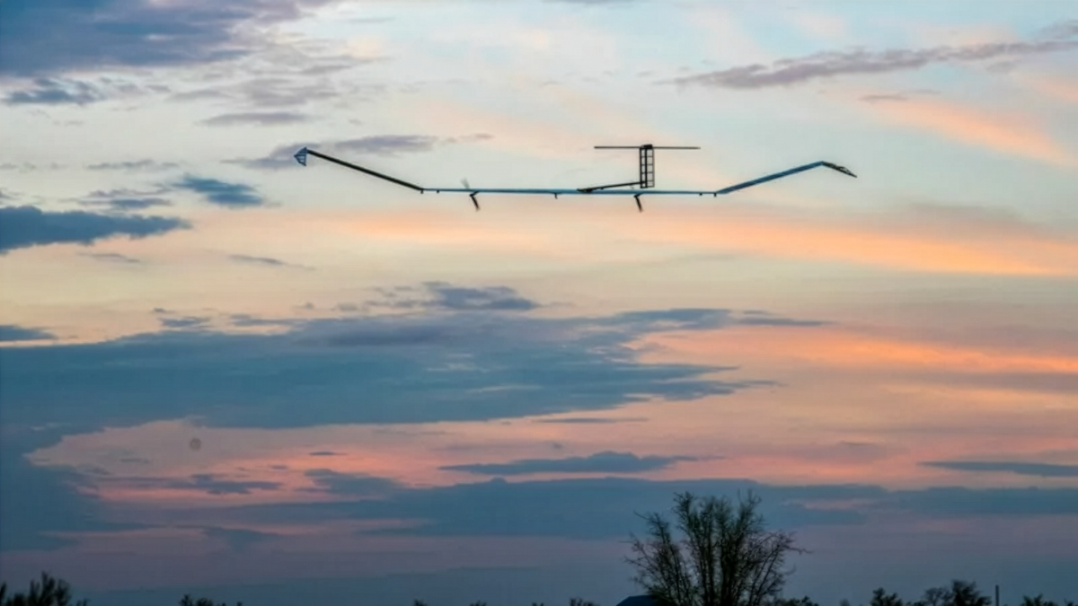
High-altitude platform stations (HAPS) operate at approximately 18 to 25 kilometers altitude, above commercial aviation and most weather, and are intended to provide regional coverage from a single platform. AALTO's Zephyr fixed-wing solar-electric aircraft holds a publicly reported endurance record of 67 days from an April 2025 flight [4][5]. SoftBank, in partnership with Sceye, plans pre-commercial HAPS service in Japan starting in 2026 oriented toward disaster restoration and stable connectivity in mountainous and remote areas [26]. Airbus and NTT DOCOMO demonstrated stratospheric LTE connectivity from a Zephyr aircraft in 2021, with successful data transmission tested at distances up to 140 kilometers using a 450 MHz bandwidth in the 2 GHz spectrum band [27]. NTT DOCOMO, Space Compass, Mizuho Bank, and Development Bank of Japan announced a USD 100 million investment vehicle, HAPS JAPAN, into AALTO in 2024 [28]. These figures and milestones are derived from press releases and industry reporting; the technical readiness of HAPS for sustained commercial service across diverse latitudes and weather conditions remains, in the assessment of independent commentators, partially unproven [4][29].
3.2 Mesh Networking Protocols and Their Limits
The dominant mesh protocols considered in the literature for UAV and disaster applications are IEEE 802.11s (which standardizes the Hybrid Wireless Mesh Protocol, HWMP, as its default routing protocol), Optimized Link State Routing (OLSR, defined in IETF RFC 3626), and the Better Approach to Mobile Ad-hoc Networking (B.A.T.M.A.N., developed by the Freifunk community in response to perceived limitations of OLSR for large-scale mesh deployments) [30] [31].
Peer-reviewed work has established that 802.11s with HWMP can rapidly construct a mesh "out of nothing" in disaster scenarios but exhibits performance degradation under high node mobility and high failure rates; geographic routing algorithms such as Greedy Perimeter Stateless Routing (GPSR) outperform HWMP at scale and under failure [30][32]. Recent research evaluating B.A.T.M.A.N. V for aerial and ground-based mesh networks concludes that the protocol's bio-inspired, proactive design provides reasonable baseline performance but benefits substantially from mobility-predictive extensions in highly dynamic UAV scenarios [31]. Federated learning approaches to enhance B.A.T.M.A.N. routing decisions for swarm-based multi-hop networks are an active research direction but not yet a fielded capability [33].
A practical implication is that no single off-the-shelf protocol robustly solves the combined problem of high node mobility, intermittent connectivity, and adversarial jamming. Operational deployments to date appear to use either commercial cellular protocols (LTE, 5G NR) on aerial nodes acting as base stations, with conventional terrestrial backhaul, or proprietary mesh layers built atop commercial Wi-Fi hardware. The MITRE StarMesh++ system developed for the Ukrainian Red Cross Society combined Starlink terminals, mesh-style networking, and battery powered solar kits, but the underlying mesh protocol is not described in publicly available documentation [34].
3.3 Radio Frequency Considerations and Link Budgets
Air-to-ground propagation differs materially from terrestrial-to-terrestrial. At low altitudes, aerial base stations enjoy higher line-of-sight (LoS) probability and reduced building obstruction, improving link budget; at higher altitudes, free-space path loss dominates, and signals from aerial transmitters can interfere with multiple terrestrial cells due to LoS to many co-channel base stations [35][36]. The Al-Hourani air-to-ground channel model, widely cited in the literature, treats path loss as the probabilistic combination of LoS and non-line-of-sight (NLoS) components and has been used to optimize three-dimensional base station placement [36][37]. The 3GPP Technical Report 36.777, completed in December 2017, formalized the conclusion that existing LTE networks can serve aerial vehicles but that interference and mobility impose specification-level enhancements as drone density rises [38][39]. The technical report has become the foundational reference for cellular-connected UAVs.
3.4 Integration with 5G and Non-Terrestrial Networks
3GPP Release 17, frozen in 2022, introduced the first normative specifications for non-terrestrial networks (NTN), supporting 5G New Radio (NR) and narrowband IoT over satellites and HAPS using a "transparent payload" (bent-pipe) architecture [40][41]. Release 18 expanded NTN with IoT enhancements, additional frequency bands, support for store-and-forward operation with regenerative payloads, and improved mobility between terrestrial networks and NTN cells [41] [42]. The 3GPP NTN specification recognizes UAS (including tethered UAS, lighter-than-air, and heavier-than-air platforms operating between 8 and 50 kilometers altitude) as legitimate platforms within the NTN family alongside LEO, MEO, and GEO satellites [40]. HAPS in particular offer round-trip latency in the range of 0.1 to 1 millisecond, comparable to or better than terrestrial cellular and substantially better than GEO satellite latency of approximately 540 milliseconds round trip [43]. This positions HAPS as the latency-favored NTN tier for emergency voice and interactive services.

3.5 Backhaul and Power Architectures
A core engineering requirement for any aerial communications node is backhaul. AT&T's published toolbox of options includes fiber, GEO satellite, LEO satellite, microwave, and emerging free-space optical and tropospheric scatter approaches [44]. Power approaches include tethered electric, battery, solar, gasoline, hybrid, and laser power transmission [44]. Lighter-than-air designs benefit disproportionately from large surface area for solar generation and high payload tolerance, with Sceye reporting payload capacities up to 250 kilograms versus the few-kilogram payloads typical of fixed-wing solar HAPS [4]. The recurrence of fiber-tethered architectures across both AT&T (Flying COW, FirstNet One) and Verizon (THOR's onboard Easy Aerial Raptor) deployments suggests that operational practitioners regard a wired tether as the most reliable backhaul for sustained service in disaster zones where terrestrial fiber is intact at the deployment site [17][45].
4. Key Stakeholders and Industry Landscape
4.1 U.S. Telecommunications Operators
AT&T's Flying COW program is the most extensively documented carrier-led aerial communications capability in the United States. AT&T characterizes the program as part of its Network Disaster Recovery (NDR) fleet, which exceeds 750 deployable assets and reflects more than USD 1 billion in cumulative investment since 1992 [46]. The dedicated FirstNet fleet, available at no additional charge to FirstNet subscribers, has grown from 76 assets at the time of FirstNet One's launch in 2019–2020 to roughly 190 portable assets in 2025, including Compact Rapid Deployables and miniCRDs [22][46][47]. AT&T's Response Operations Group (ROG) reported triaging more than 2,165 deployable solutions in 2025 across incidents including the Maui Wildfires, Hurricane Helene, the California wildfires, and the Texas floods [46]. These deployment volumes are AT&T disclosures; independent verification of utilization, customer impact, and outcome metrics is limited in public reporting.
Verizon's Tactical Humanitarian Operations Response (THOR) vehicle, unveiled at Marine Corps Air Station Miramar in July 2021 and built on a modified Ford F650 chassis, integrates 5G Ultra Wideband, mobile edge computing, multiple radio interoperability options, and an onboard tethered drone (Easy Aerial Raptor) [45][48][49]. Verizon's first operational deployment of THOR against Hurricane Ian in September 2022 included a tethered drone on Sanibel Island providing cellular coverage over a five- to seven-mile radius [50]. THOR is described in Verizon and partner materials as a prototype rather than a production system, and the company has not publicly disclosed plans for a fleet [49].
4.2 Public Safety Network Operators
FirstNet (United States) operates under a public-private partnership between the First Responder Network Authority and AT&T, established in 2017 [51]. The United Kingdom's Emergency Services Network (ESN), operated by EE/BT under contract with the Home Office, is on a parallel trajectory but with a slower deployment timeline. South Korea's SafeNet (also referred to as PS-LTE) was an earlier large-scale national public safety LTE deployment. These networks are the principal regulatory anchors for aerial deployable integration, since priority access, preemption, and dedicated band assignments (Band 14 in the U.S. case) provide a predictable spectrum environment for airborne base stations.
In Japan, the five major mobile carriers (NTT DOCOMO, KDDI, Okinawa Cellular, SoftBank, and Rakuten Mobile) announced "JAPAN Roaming," a nationwide emergency roaming service launching April 1, 2026, that allows users to temporarily connect to another carrier's 4G LTE network during major disasters or significant outages [52]. This represents an institutionalization of mutual-aid network access and a complement to aerial deployable strategies.
4.3 HAPS Vendors and Their Backers
Three commercial efforts dominate the HAPS landscape. AALTO, an Airbus subsidiary spun out in 2023, manufactures the Zephyr solar-electric fixed-wing platform, which has demonstrated 67-day continuous flight and connectivity demonstrations with NTT DOCOMO and BT Group [4][27][53]. Sceye, based in New Mexico, develops a helium-filled stratospheric airship with a payload capacity reportedly up to 250 kilograms, partnered with SoftBank for pre-commercial Japan service [4][26]. SoftBank's HAPS program, formerly conducted through HAPSMobile (absorbed into SoftBank Corp. in October 2023), centers on the Sunglider fixed-wing platform, which achieved a stratospheric LTE test in September 2020 and a 5G test in September 2023 [26]. Thales Alenia Space's Stratobus airship and Raven Aerostar's Thunderhead balloon platform, the latter benefiting from technology development that traces in part to Project Loon; represent complementary entrants [29][54]. A consortium led by NTT DOCOMO including Space Compass, Mizuho Bank, and the Development Bank of Japan committed approximately USD 100 million to AALTO in 2024 through HAPS JAPAN [28].
4.4 Satellite Backhaul Providers
SpaceX's Starlink is now the de facto reference architecture for emergency satellite broadband. By March 2022, more than 5,000 Starlink terminals were operating in Ukraine, with the figure subsequently growing to as many as 200,000 as of 2025 [9]. Eutelsat OneWeb provides a complementary LEO architecture, while Iridium provides L-band global voice and narrowband data with a long history of disaster response use. The Belfer Center's 2023 analysis of Starlink in Ukraine cautions that reliance on a single privately controlled commercial satellite operator for critical wartime infrastructure introduces governance and continuity risks not adequately mitigated through arms-length procurement [7]. SpaceX announced its government-focused Starshield program in late 2022 [8].
4.5 Defense and Tactical Vendors
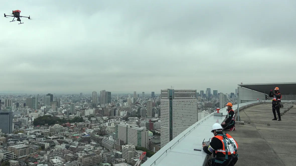
Hoverfly Technologies and Zenith Aerotech are among the principal tethered-drone vendors marketing to defense and homeland security customers, with platforms used for ISR, communications relay, and counter-UAS missions [18][19]. ACSL (Japan) provides tethered and BVLOS-capable platforms used by NTT DOCOMO and Japanese government agencies for typhoon response and remote logistics [55]. Skydio's expansion into Japan with KDDI and NTT DOCOMO (announced 2025) reflects the integration of autonomous "drone-in-a-box" architectures with carrier networks for inspection, disaster response, and Drone-as-First Responder applications [56].
4.6 Humanitarian and Multilateral Stakeholders
The UN World Food Programme leads the Emergency Telecommunications Cluster (ETC), the global multi-agency network responsible for coordinated humanitarian communications. Since 2005 the ETC has responded to more than 40 humanitarian emergencies, providing telephony, internet connectivity, and security communications services typically within 48 hours of activation [57]. NetHope has supported point-to-point microwave deployment in Puerto Rico following Maria, and emergency.lu (a Luxembourg public-private partnership) provides mobile satellite-based deployable telecommunications [58][59]. MITRE's StarMesh++ system, developed for the Ukrainian Red Cross Society, illustrates a hybrid Starlink-and-mesh architecture targeted at humanitarian applications [34].

5. Economic and Market Dynamics
5.1 Market Sizing and the Divergence of Estimates
Industry estimates for adjacent market categories diverge substantially. Fortune Business Insights values the global UAV market at USD 41.27 billion in 2025, projecting USD 160.44 billion by 2034 at a 16.40 percent compound annual growth rate [60]. MarketsandMarkets estimates the narrower drone communication market at USD 2.46 billion in 2024 [61]. Research and Markets projects the drone swarm mesh network sub-segment to reach USD 4.33 billion by 2030 at a 23.3 percent CAGR, and the drone swarm systems market at USD 8.28 billion by 2030 at 27 percent CAGR [62][63]. Mordor Intelligence values the UAV payload and subsystems market at USD 7.86 billion in 2025, growing to USD 12.41 billion by 2030 [64].
These figures are not directly comparable. Differences arise from scope (defense vs. commercial, hardware-only vs. systems-and-services), geographic coverage, and methodological choices regarding what constitutes a "communication" or "mesh" component versus a general UAV system. The variance also reflects analyst houses' commercial incentives to define markets in ways favorable to their target subscribers. Senior decision-makers should treat any single market figure as indicative only and instead reason from underlying drivers; defense budget allocations to unmanned systems, FirstNet-equivalent public safety procurement, HAPS ecosystem investment, and disaster response budgets when evaluating capital deployment. The U.S. Department of Defense earmarked approximately USD 10.1 billion for unmanned vehicle acquisition and R&D in fiscal 2025, providing a more reliable demand-side anchor than top-down market sizing [64].
5.2 Cost Structures and Unit Economics
Unit cost data for aerial communications platforms is fragmentary in public reporting. AT&T has not disclosed per-unit costs for the Flying COW or FirstNet One. Industry context suggests that tethered rotary platforms with telecommunications payloads typically range from the low hundreds of thousands of U.S. dollars to over USD 1 million depending on payload complexity. Aerostats such as FirstNet One sit higher in the cost stack due to ground infrastructure, helium logistics, and operational labor. HAPS platforms are substantially more expensive: AALTO's reported USD 100 million investment from the NTT DOCOMO-led consortium is suggestive of the order of magnitude, although it represents equity capital rather than per-unit cost [28]. Operational costs are dominated by skilled personnel (AT&T notes that tethered Flying COW operations require two pilots for 24-hour coverage with rotation) [22] and by spectrum, backhaul, and maintenance.
5.3 Public-Private Partnership Models
The dominant economic model for sustained aerial emergency communications combines a long-term carrier or vendor commitment (e.g., AT&T's FirstNet contract, SoftBank-Sceye partnership) with no-cost-at-event-of-use access for public safety subscribers, financed by base contract revenue and broader commercial subscriber growth. Verizon Frontline operates a similar model without an exclusive federal contract. The Police Executive Research Forum's 2020 case study on FirstNet deployables describes more than 40 secure storage locations across the United States supporting a 14-hour delivery target [47][51]. These prepositioning agreements appear, on available public evidence, to be the most effective cost structure for ensuring rapid deployable availability, though the absence of competing incumbent networks with similarly scaled deployable fleets makes comparative cost-effectiveness assessment difficult.
5.4 Investment Themes for Institutional Capital
For institutional investors evaluating dual-use technology portfolios, four investment themes emerge from the available evidence. First, HAPS commercialization is concentrated in three to five vendors with substantial strategic backers (Airbus, SoftBank, NTT, Thales, World Mobile). Concentration risk is meaningful. Second, mesh networking software, including AI-enhanced routing protocols, is a fragmented but growing sub-segment with relatively low capital intensity and dual-use applicability. Third, tethered drone vendors with NDAA-compliant supply chains are positioned to benefit from FCC Covered List restrictions on foreign-produced UAS [10][11]. Fourth, satellite backhaul (LEO) is undergoing structural change, with the Starlink–Ukraine experience suggesting that government customers will increasingly seek diversified or sovereign LEO alternatives [7][9].
6.1 Spectrum Allocation and Authorization
Aerial communications nodes occupy a spectrum environment in tension with two FCC objectives: maximizing spectral efficiency for terrestrial mobile broadband and maintaining airspace safety. Parts 22 and 96 of FCC rules explicitly bar airborne use of Cellular Radiotelephone Service and Citizens Broadband Radio Service (CBRS) spectrum, respectively, and the U.S. Table of Frequency Allocations prohibits aeronautical mobile use across portions of the 1670–1675 MHz, 1.4 GHz, 2.3 GHz, and 3.7 GHz bands [65]. A 2025 FCC Notice of Inquiry on UAS spectrum solicits comment on relaxing these restrictions to enable more intensive aerial operations, including in 800 MHz Cellular and other flexible-use bands [65]. The Commission's 2024 order on 5 GHz drone control-link rules and its dynamic frequency management system framework represent incremental moves toward more flexible aerial spectrum access [66].
For emergency deployments, the FCC's Special Temporary Authority (STA) mechanism remains the practical regulatory pathway. The Commission issued nearly 900 STAs to allow radio facilities to operate following Hurricane Maria, the longest period of FCC outage data collection in the agency's history [14]. AT&T's initial Flying COW deployment in Puerto Rico required FAA special authorization because the platform exceeded the 55-pound Part 107 limit at the time of operation [67].
6.2 The FCC Covered List and the Drone Industrial Base
On December 22, 2025, the FCC's Public Safety and Homeland Security Bureau added "uncrewed aircraft systems and UAS critical components produced in a foreign country" to its Covered List, effectively barring new foreign-made UAS and key components from receiving the FCC equipment authorizations required for U.S. sale and operation [10]. The action implemented a Fiscal Year 2025 National Defense Authorization Act mandate and an executive branch national security determination [10][11]. A January 2026 follow-up exempted UAS on the Department of Defense Defense Contract Management Agency's "Blue UAS Cleared List" and components qualifying as "domestic end products" under Buy American rules, with both exemptions sunsetting January 1, 2027 unless extended [11]. Devices authorized before December 22, 2025 may continue to be imported, marketed, and used unless materially modified [11].
For emergency communications planners, the practical implication is that procurement pipelines reliant on Chinese or other foreign-produced UAS platforms (including DJI and Autel models that historically dominated the public safety and disaster response markets) are now subject to substantial uncertainty. The cost structure of NDAA-compliant alternatives is generally higher, and the supply chain remains constrained.
6.3 3GPP Standardization for Aerial and Non-Terrestrial Networks
3GPP Technical Report 36.777, completed December 2017, established the standards body's view that LTE networks could provide service to aerial vehicles with manageable interference and mobility tradeoffs [38][39]. Release 17 introduced normative NTN support for 5G NR and NB IoT/eMTC, with HAPS treated as a covered platform [40][41]. Release 18 extended NTN with IoT enhancements, additional bands, regenerative payload support, and store-and-forward operation [41][42]. Release 19 study items continue work on enhanced security, spectrum sharing, and integration with terrestrial networks. The GSMA Foundry, NGMN Alliance, and HAPS Alliance provide industry coordination layers atop 3GPP standardization [40].
6.4 IEEE and IETF Mesh Standards
IEEE 802.11s, finalized in July 2011 as an amendment to 802.11-2007, defines mesh networking among Wi-Fi devices and remains the reference standard for wireless mesh networks [30]. IETF RFC 3626 (OLSR) and RFC 7181 (OLSRv2) are the principal IETF mesh routing references. B.A.T.M.A.N. and B.A.T.M.A.N. Advanced are open community efforts not standardized by IEEE or IETF but widely deployed in community wireless networks. Standards bodies have not yet promulgated a UAV-specific mesh routing standard suitable for high-mobility, high-failure-rate environments; this remains a research gap.
6.5 Aviation Regulation
The FAA's Part 107 framework governs U.S. small UAS operations and has been the principal regulatory authority for tethered Flying COW operations [17]. Beyond visual line of sight (BVLOS) operations require waivers, although the FAA's evolving BVLOS rulemaking is moving toward routine authorization for qualifying commercial operations. The European Union Aviation Safety Agency (EASA) has issued its own UAS framework, and Japan amended its Civil Aeronautics Act in 2018 to permit Level 3 BVLOS operations, enabling Japan Post and ANA Holdings emergency delivery experiments [55]. Different national aviation regimes will impose materially different operational constraints on aerial communications nodes, particularly for HAPS, which operate above conventional commercial airspace, but whose ascent and descent corridors must be coordinated.
6.6 Export Controls and the Wassenaar Arrangement
The Wassenaar Arrangement on Export Controls for Conventional Arms and Dual-Use Goods and Technologies, established in 1996, is the principal multilateral framework governing dual use technology export coordination [68][69]. The arrangement is non-binding and operates through 42 participating states' aligned national export controls, with annual updates to the dual-use and munitions lists [69]. UAS endurance, range, and payload thresholds determine listing on either the dual-use list (for civilian-primary technologies with potential military application) or the munitions list. A 2024 U.S. Bureau of Industry and Security interim rule allowed certain commercial UAVs in Export Control Classification Number 9A012.a.1 (described as having maximum endurance under one hour) to be exported without a license to most Wassenaar Country Group A:1 states [70]. The 2025 reinterpretation of the Missile Technology Control Regime to enable Reaper-class drone exports, in U.S. policy commentary, was framed as a competitive response to Israeli, Turkish, and Chinese offerings [70]. U.S. International Traffic in Arms Regulations (ITAR) governs explicitly military UAS exports, while the Export Administration Regulations (EAR) govern dual-use commercial UAS.
7. Geopolitical and Strategic Dimensions
7.1 Lessons from Ukraine
The Russo-Ukrainian war has produced the largest body of operational data on commercial communications technology under sustained adversarial pressure. Starlink service was activated on February 26, 2022, two days after Ukrainian Vice Prime Minister Mykhailo Fedorov's public request to Elon Musk, with the first terminals arriving in Kyiv within 48 hours [9]. By April 2022 the Ukrainian government relied on Starlink for presidential broadcasts, mobile operator backhaul, hospital connectivity, railway operations, and frontline military command [9]. Hospitals received approximately 600 terminals in a single month [9].
Three operationally significant patterns have emerged. First, commercial satellite services are a viable substitute for damaged terrestrial infrastructure when bandwidth and terminal supply are sufficient, but reliance on a single privately controlled provider creates governance risks [7][8]. Second, contested electromagnetic environments produce mesh-network adaptation as a counter-countermeasure: Ukrainian reporting documents Russian use of mesh network modems on Shahed and Geran drones to extend operator control distances up to 600 kilometers via airborne communication chains, with relay stations established in Belarus to support cross-border operations [71]. Third, even commercial encrypted satellite communications can be defeated through registration controls, as demonstrated by SpaceX's February 2026 cutoff of Russian-registered terminals, which Ukrainian sources and the Atlantic Council describe as having materially affected Russian frontline operations [71][72].
The MITRE-developed Starlink Advantage / StarMesh++ kits, deployed with the Ukrainian Red Cross Society, illustrate the integration model: Starlink terminals provide backhaul, mesh networking extends coverage area, solar panels and batteries provide power continuity, and virtual private networks plus point-to-point radios provide cybersecurity and physical standoff from kinetic targeting [34]. As of MITRE's reporting nine of these kits remained operational in Ukraine [34]
7.2 GPS Spoofing and Electronic Warfare Implications
Russian and Ukrainian electronic warfare units have used GPS spoofing extensively. Russian systems including the Krasukha-4 and Borisoglebsk-2 have reportedly used spoofing to mislead Ukrainian drones, while Ukraine's "Pokrova" nationwide electronic warfare system, described in a paper by former Commander-in-Chief Valerii Zaluzhnyi, is reported to provide spoofing coverage along the entire line of contact and most of Ukrainian territory [73][74]. Civilian impacts include automatic time zone shifts on smartphones during air raid alarms, a documented externality of military spoofing [75][76]. CSIS analysis underscores that electronic warfare has become "one of the most dominant features of the modern battlefield," with spoofing and jamming detected on Russia's western borders, in Israel, and in the Baltic Sea [77].
For emergency communications planners, these findings imply that any aerial communications architecture relying on GNSS for navigation, time synchronization, or positioning must assume spoofing as a baseline threat in adjacent or conflict-affected zones. Multi-constellation receivers (GPS, GLONASS, Galileo, BeiDou), inertial navigation backups, and time-distribution alternatives such as Precision Time Protocol over hardened backhaul are mitigations but not full solutions.

7.3 Sovereignty, Public Purpose, and the Privatization of Critical Infrastructure
The Belfer Center's analysis of Starlink in Ukraine identifies three structural risks of relying on commercial dual-use technology in crisis: volatility tied to private actor preferences, divergence between commercial decision-making and broader public-purpose ecosystems, and over attribution of operational success to a single technology vendor [7]. Ukraine's announced 2026 plans to develop a national military mobile operator with private 4G/5G networks, leveraging "big three" Ukrainian operator infrastructure (Kyivstar, Vodafone Ukraine, lifecell), reflect a move toward sovereign communications redundancy [78]. Other states, including in NATO, are likely to draw analogous conclusions about combined commercial-sovereign architectures.
7.4 Implications for Allied Defense and Humanitarian Posture
For NATO and Indo-Pacific allies, three strategic implications follow. First, prepositioned aerial communications nodes in geographies vulnerable to compound shock (Pacific island chains, Baltic states, Caribbean basin) are now operationally validated in U.S. and Japanese practice and represent a transferable model. Second, the FCC Covered List actions imply allied governments will face pressure to align UAS supply chain restrictions or accept divergent procurement frameworks. Third, the integration of HAPS with national disaster restoration strategies (exemplified by Japan's HAPS-NTN policy framework and SoftBank-Sceye-AALTO commercial pilots) suggests an emerging template that could be adapted to Mediterranean, Caribbean, and South Pacific contexts.
8. Risk Analysis
The risk analysis below uses structured prose rather than a tabular matrix because the risks are interdependent and time-phased in ways that a static matrix obscures. Risks are organized by category (technical, regulatory, financial, adoption) and time horizon (short-term, 1–3 years; medium-term, 3–7 years; long-term, 7+ years).
8.1 Short-Term Risks (1–3 Years)
Spectrum availability and authorization friction. The FCC's STA mechanism, while functional, was found by GAO in 2021 to suffer from inadequate role clarity following Hurricane Maria [14]. Repeat large-scale events affecting multiple jurisdictions may stress STA throughput. Most exposed: territorial governments in the Caribbean and Pacific. Mitigation: standing pre-event STAs and clearer DHS National Response Framework guidance for FCC roles.
Supply chain disruption from UAS Covered List. The December 2025 FCC Covered List action removes a principal source of public safety drone hardware from new authorization, with the Blue UAS exemption sunsetting January 1, 2027 [10][11]. Most exposed: state and local public safety agencies dependent on previously authorized DJI and Autel platforms whose models reach end-of-life. Mitigation: accelerated procurement of NDAA-compliant alternatives; budget supplements for higher unit costs.
Single-vendor dependence in satellite backhaul. The Starlink experience in Ukraine illustrates that operational dependence on a single privately controlled LEO provider exposes governments to changes in commercial preferences, sanctions interpretations, and unilateral service modifications [7][72]. Most exposed: humanitarian agencies, NATO partners with limited sovereign LEO capability. Mitigation: multi-vendor satellite contracts, including OneWeb and Iridium; sovereign or alliance-shared LEO investments.
Operator skill scarcity. Tethered drone operations require qualified pilots in Part 107 jurisdictions, and FAA and EASA waiver processes for BVLOS, large-platform, and high-altitude operations are personnel-intensive [17][22]. Most exposed: smaller emergency management agencies without standing aviation programs. Mitigation: shared service models (FirstNet Response Operations Group is the canonical example); cross-trained partnerships with local National Guard aviation units.
8.2 Medium-Term Risks (3–7 Years)
Mesh protocol scalability under high node mobility. Peer-reviewed evidence suggests existing 802.11s HWMP and B.A.T.M.A.N. protocols degrade under high failure rates and mobility, and AI enhanced routing remains a research direction rather than a fielded capability [31][32][33]. Most exposed: defense buyers procuring swarm-as-a-service capabilities for which mesh routing is the load-bearing assumption. Mitigation: investment in protocol research; field testbeds (DARPA OFFSET-style exercises); hybrid architectures combining mesh with cellular base station functionality.
Cybersecurity attack surface expansion. Aerial nodes introduce new attack surfaces including over-the-air firmware updates, command-and-control links, and tether-based data ingress. ENISA's 5G threat landscape work documents the broader 5G NTN attack surface, including network function virtualization vulnerabilities and inter-vendor trust assumptions [79][80][81]. Most exposed: civilian operators integrating aerial nodes with commercial 5G cores; humanitarian operators with limited security operations capacity. Mitigation: zero-trust architectures, encrypted command-and-control, hardware security modules, and conformance testing under ENISA and equivalent national frameworks.
HAPS commercialization shortfalls. Industry messaging projects HAPS commercial service launches in Japan in 2026 and broader rollouts thereafter, but lighter-than-air and fixed-wing platforms have not, on publicly available evidence, demonstrated multi-month commercial operation across diverse weather regimes [4][5][26]. The Project Loon experience, which Alphabet wound down in 2021 despite material technical and operational accomplishments in Peru and Puerto Rico, indicates that HAPS economics can fail even when the technology is partially proven [82]. Most exposed: institutional investors with concentrated HAPS exposure; governments planning disaster restoration architectures contingent on HAPS availability. Mitigation: hedged investment thesis incorporating LEO alternatives; staged government contracts with performance milestones.
Diverging regulatory regimes for cross-border operations. Wassenaar, ITAR, EAR, EU Dual Use Regulation, and FCC Covered List rules are evolving in directions that increasingly diverge across allied jurisdictions [10][68][69][70]. Most exposed: humanitarian organizations operating cross-border deployments; multinational telecoms with global emergency response footprints. Mitigation: jurisdictional pre-clearance agreements; modular hardware architectures permitting region-specific component substitution.
8.3 Long-Term Risks (7+ Years)
Climate-driven disaster frequency exceeding deployable capacity. AT&T's NDR fleet of 750+ assets and FirstNet's 190+ dedicated assets represent a substantial commitment, but compound disasters, such as multiple simultaneous hurricane, wildfire, and seismic events, could exceed even this capacity [46][51]. Climate science consensus suggests increasing frequency and severity of compound events. Most exposed: regions with limited domestic aviation industry such as Caribbean states. Mitigation: international mutual-aid frameworks; expansion of Emergency Telecommunications Cluster prepositioning [57].
Strategic vulnerability of stratospheric assets. As HAPS achieve commercial scale and become integrated into national disaster restoration plans, their stratospheric position (above commercial aviation but below LEO) creates a class of asset that is vulnerable to state-level kinetic and electronic countermeasures. The 2023 Chinese balloon incident over the United States illustrated the political salience of stratospheric assets even before commercial HAPS reach scale. Most exposed: civilian operators of single-platform HAPS deployments. Mitigation: distributed HAPS constellations; hardened command-and-control links; international norms development for stratospheric civilian assets
Erosion of dual-use boundary. As mesh networking, autonomous flight, and AI routing advance, the technical distinction between humanitarian and military aerial communications platforms continues to narrow. The Wassenaar Arrangement's existing thresholds (endurance, range, payload) may not capture the relevant dual-use risks [69][70]. Most exposed: civilian vendors whose products may be reclassified; humanitarian operators whose tools may face new export restrictions. Mitigation: engagement in Wassenaar review processes; pre-clearance arrangements with national export authorities.
Sovereign LEO and HAPS competition reshaping markets. China's Guo Wang and Qianfan constellations, the European Union's IRIS² constellation, and Japanese-Korean HAPS investments are all positioned to challenge U.S. commercial dominance in non-terrestrial networks. The competitive landscape in 2032 may bear little resemblance to 2025. Most exposed: investors with concentrated commercial U.S. exposure; allied governments dependent on single vendor architectures.
9. Strategic Recommendations by Audience
9.1 Recommendations for Government Emergency Management Agencies
Recommendation 9.1.1. Establish or expand standing pre-event Special Temporary Authority frameworks with the FCC (or analogous national regulator) that automatically authorize aerial deployable operations in pre-defined disaster declaration zones. Rationale: The 2017 Maria experience demonstrated that authorization friction extended communications restoration timelines by days [14][67]. Timeframe: 12–24 months. Principal obstacles: Inter-agency coordination between FCC, FAA, DHS, and FEMA; airspace deconfliction with active disaster response aviation.
Recommendation 9.1.2. Procure a layered architecture combining tethered rotary platforms (rapid deployment, 24-hour-plus persistence), aerostats (multi-week persistence, larger coverage), and satellite backhaul redundancy across at least two LEO providers. Rationale: No single platform class addresses the full range of disaster scenarios; a 2017–2025 review of FirstNet, AT&T, Verizon, and Japanese deployments shows that operationally effective restoration consistently relied on multiple platform types in combination [22][46][50]. Timeframe: 24–48 months for fleet build-out. Principal obstacles: Procurement budget constraints, particularly for state and territorial governments; supply chain dependence on NDAA-compliant vendors.
Recommendation 9.1.3. Negotiate prepositioning agreements with multiple commercial telecom operators rather than relying on a single carrier. Rationale: Japan's "JAPAN Roaming" initiative among five operators represents a more resilient model than single-carrier dependence [52]. Timeframe: 18–36 months. Principal obstacles: Competitive sensitivities among carriers; regulatory antitrust considerations.
9.2 Recommendations for Telecommunications Operators
Recommendation 9.2.1. Invest in fleet diversification across tethered, aerostat, and HAPS platforms, with explicit performance contracts tied to disaster response time-to-restoration metrics. Rationale: AT&T's progression from Flying COW to FirstNet One to announced HAPS development represents the canonical fleet evolution [44]; Verizon's THOR remains a prototype rather than a fleet. Timeframe: 36–60 months. Principal obstacles: Capital intensity; uncertain HAPS commercialization timelines.
Recommendation 9.2.2. Develop standing contracts with public safety customers that quantify deployable availability commitments (for example, FirstNet's 14-hour delivery objective) rather than relying on best-effort commitments [47]. Rationale: Public safety customers' purchasing decisions are increasingly driven by demonstrated deployable performance rather than baseline coverage metrics. Timeframe: 12–24 months. Principal obstacles: Internal cost allocation between commercial and public safety service tiers.
Recommendation 9.2.3. Develop multi-vendor satellite backhaul integration to reduce single LEO-provider dependence. Rationale: The Starlink–Ukraine case demonstrates governance risks of single-vendor LEO reliance [7]. Timeframe: 24–36 months. Principal obstacles: Multi-vendor terminal complexity; competing satellite operators' technical specifications.
9.3 Recommendations for Defense Ministries
Recommendation 9.3.1. Treat sovereign or alliance-shared LEO and HAPS access as a strategic capability, not a commercial purchase. Rationale: Ukraine's announced military mobile operator initiative reflects the conclusion drawn from three years of Starlink dependence that sovereign communications redundancy is a national security requirement [78]. Timeframe: 5–10 years for full deployment. Principal obstacles: Capital requirements; alliance burden-sharing politics; competitive dynamics with U.S. commercial providers.
Recommendation 9.3.2. Establish jamming-resistant and spoofing-resistant time and position distribution alternatives to GNSS for aerial communications nodes operating in or near conflict zones. Rationale: GPS spoofing is now a routine feature of contested electromagnetic environments [73][74][77]. Timeframe: 24–60 months. Principal obstacles: Cost of inertial-grade backup systems; coordination with allied PNT (positioning, navigation, timing) initiatives.
Recommendation 9.3.3. Invest in mesh routing protocol research for high-mobility, high-failure environments, including AI-enhanced routing. Rationale: Existing 802.11s HWMP and B.A.T.M.A.N. protocols are inadequate for swarm operations, and DARPA OFFSET-style research has demonstrated proof-of-concept performance but not fielded capability [33]. Timeframe: 5–10 years. Principal obstacles: Research-to-fielding lead times; integration with existing tactical radio architectures.
9.4 Recommendations for Humanitarian NGOs
Recommendation 9.4.1. Standardize on Emergency Telecommunications Cluster–compatible architectures and pre-position equipment in regional hubs aligned with high-risk geographies. Rationale: ETC's track record across 40+ humanitarian emergencies since 2005 represents the strongest aggregate performance in humanitarian communications [57]. Timeframe: Ongoing. Principal obstacles: Funding cycles; coordination with national authorities.
Recommendation 9.4.2. Develop hybrid Starlink-mesh architectures modeled on MITRE StarMesh++ for field deployment in conflict and disaster zones. Rationale: Documented operational success with Ukrainian Red Cross Society deployments [34]. Timeframe : 12–24 months. Principal obstacles: Export controls on integrated kits; cybersecurity expertise within humanitarian organizations.
9.5 Recommendations for Institutional Investors
Recommendation 9.5.1. Treat market sizing estimates as indicative rather than determinative, and reason from underlying drivers (defense unmanned systems budgets, FirstNet-equivalent public safety procurement, disaster response budgets). Rationale: Divergence among industry estimates ranges from approximately USD 2.5 billion (drone communications, 2024) to USD 41 billion (UAV market, 2025) and reflects scope and methodological choices rather than disagreement about fundamental demand drivers [60][61][62][64]. Timeframe: Immediate. Principal obstacles: Limited disclosure from incumbent operators on deployable program economics
Recommendation 9.5.2. Diversify exposure across HAPS vendors and complementary LEO satellite providers rather than concentrating in single-vendor positions. Rationale: HAPS commercialization remains pre-revenue across most vendors, and the Project Loon experience suggests that even technically successful platforms can fail commercially [82]. Timeframe: Portfolio rebalancing over 12–24 months. Principal obstacles: Limited public market access to HAPS vendors; concentration of strategic backers.
9.6 Recommendations for Regulators and Standards Bodies
Recommendation 9.6.1. Accelerate FCC and equivalent national rulemakings to permit aerial use of additional flexible-use bands under controlled conditions, particularly for emergency deployments. Rationale: The 2025 FCC Notice of Inquiry on UAS spectrum acknowledges existing prohibitions on cellular and CBRS airborne use that limit aerial deployable utility [65]. Timeframe: 18–36 months. Principal obstacles: Interference protection of incumbent terrestrial operations; coordination with NTIA and FAA.
Recommendation 9.6.2. Develop a dedicated 3GPP work item for UAV-specific mesh routing extensions to NTN, addressing high-mobility and contested-environment performance. Rationale: 3GPP NTN work to date has focused on satellite and HAPS architectures with limited attention to UAV-specific mesh concerns [40][41][42]. Timeframe : Release 20+ work program (2027–2030). Principal obstacles: Competing release priorities; consensus-building across global participants.
Recommendation 9.6.3. Coordinate Wassenaar, EAR, ITAR, and EU Dual-Use Regulation updates to ensure humanitarian use of aerial communications equipment is not impeded by export controls designed for offensive military UAS [68][69][70]. Rationale: The narrowing dual use boundary risks impeding legitimate humanitarian deployments. Timeframe: 36–60 months. Principal obstacles: National security review processes; divergent threat assessments across allied governments.

10. Conclusion
10.1 Synthesis of Findings
Drone-deployed mesh networks have moved from research curiosity to operational reality across several jurisdictions, but the available evidence suggests that the most consequential capabilities remain tethered platforms and aerostats integrated into commercial carrier disaster recovery fleets, complemented increasingly by satellite backhaul. The headline form factor (autonomous swarms of free-flying mesh nodes operating for extended durations in contested environments) remains substantially aspirational. HAPS commercialization is approaching commercial pilots in Japan and the United States in 2026 but has not yet demonstrated the multi-month sustained operation that its proponents project.
The most rigorously documented disaster response cases, Hurricane Maria (Puerto Rico, 2017), the 2023 Türkiye–Syria earthquakes, and Hurricane Laura (Louisiana, 2020) illustrate that aerial communications nodes are most valuable when integrated into a layered architecture with terrestrial cells on wheels, satellite backhaul, and prepositioned ground assets. Single-platform reliance is uniformly inadvisable. The Russo-Ukrainian war provides the strongest evidence that contested electromagnetic environments require both technological adaptation (mesh modems on long-range drones, sovereign communications redundancy) and governance adaptation (managed reliance on commercial dual-use providers).
10.2 Areas of Empirical Limitation
This report flags several areas where public information is limited or where commonly cited claims are weakly evidenced. Vendor coverage and capacity figures for AT&T Flying COW, Verizon THOR, and similar systems are uniformly disclosed by the operators themselves and have not been independently verified in publicly available data. HAPS endurance and commercial readiness claims are often expressed in conditional or future tense and should be read accordingly. Market sizing diverges substantially across analyst houses; no single figure is authoritative. The technical efficacy of mesh routing protocols in true high-mobility, high adversarial-pressure UAV environments remains substantially unproven outside research testbeds. The full operational record of drone-deployed mesh networks in the Türkiye–Syria response, Sub-Saharan African humanitarian operations, and many wartime deployments is incomplete in public reporting, and decision-makers should treat secondary accounts cautiously.
10.3 Outlook
The convergence of UAS, mesh networking, and emergency communications will continue, propelled by climate-driven disaster frequency, geopolitical competition over communications resilience, and standards-body integration of NTN with terrestrial 5G and 6G architectures. The institutional, regulatory, and supply chain frameworks within which this convergence operates are themselves in flux, particularly in light of the FCC Covered List actions of late 2025 and early 2026 and the ongoing rebalancing of allied positions on commercial satellite dependence. Governments, telecom operators, defense ministries, humanitarian organizations, regulators, and investors that integrate the empirical lessons documented in this report (while maintaining appropriate epistemic humility about contested or weakly evidenced claims) will be better positioned to navigate the next decade of emergency communications architecture.
11. References
[1] Pierson Wireless. 2023. “AT&T Flying COWs.” Pierson Wireless. Accessed May 2026.
https://piersonwireless.com/designengineering/att-flying-cows/.
[2] Howe, Scott. 2024. “AT&T’s Flying COW Transmits 5G Network by Tethered Drone.” Commercial UAV News, 2024.
[3] Davoli, Luca, Emanuele Pagliari, and Gianluigi Ferrari. 2021. “Hybrid LoRa-IEEE 802.11s Opportunistic Mesh Networking for Flexible UAV Swarming.” Drones 5 (2): 26.
[4] Gent, Edd. 2025. “Sceye and SoftBank Test High-Altitude Platform Station.” IEEE Spectrum, 2025.
[5] AALTO. 2025. “Zephyr High Altitude Platform Station (HAPS).” Airbus. Accessed May 2026.
https://www.airbus.com/en/products-services/defence/uas/zephyr.
[6] SoftBank Corp. 2024. “High Altitude Platform Station (HAPS).” SoftBank Corporation. Accessed May 2026.
[7] Rangel-Buitrago, María Camila, and Tyler Vandermeulen. 2023. “Starlink and the Russia-Ukraine War: A Case of Commercial Technology and Public Purpose?” Belfer Center for Science and International Affairs, Harvard Kennedy School, October 2023.
[8] Wikipedia contributors. 2025. “Starlink in the Russo-Ukrainian War.” Wikipedia. Accessed May 2026.
[9] Hardy, Geoff. 2025. “Starlink in Ukraine: What Three Years of Wartime Connectivity Taught Us.” CircleID, June 2025.
[10] U.S. Federal Communications Commission. 2025. “Public Notice DA 25-1086: Addition of Foreign-Produced UAS to the Covered List.” FCC Public Safety and Homeland Security Bureau, December 22, 2025.
[11] U.S. Federal Communications Commission. 2026. “Fact Sheet: FCC Updates Covered List to Exempt Certain Drones.” FCC, January 2026.
[12] U.S. Federal Communications Commission. 2017. “Communications Status Report for Areas Impacted by Hurricane Maria, September 22, 2017.” FCC.
[13] U.S. Federal Communications Commission. 2018. “2017 Atlantic Hurricane Season Impact on Communications: Report and Recommendations.” FCC, August 2018.
[14] U.S. Government Accountability Office. 2021. “Telecommunications: FCC Assisted in Hurricane Maria Network Restoration, but a Clarified Disaster Response Role and Enhanced Communication Are Needed.” GAO-21-297, June 2021.
[15] Yıldız Technical University and Daily Sabah. 2025. “Drone System Restores Communication During Disasters in Türkiye.” Daily Sabah, April 16, 2025.
[16] Wikipedia contributors. 2024. “2023 Turkey–Syria Earthquakes.” Wikipedia. Accessed May 2026.
[17] Hunt, Ethan. 2024. Quoted in Howe, Scott, “AT&T’s Flying COW Transmits 5G Network by Tethered Drone.” Commercial UAV News, 2024.
[18] Hoverfly Technologies. 2024. “Tethered Drone Systems.” Hoverfly Technologies. Accessed May 2026.
[19] Zenith Aerotech. 2024. “How Power and Data Links Work in Tethered Drones.” Zenith Aerotech. Accessed May 2026.
[20] Belmekki, Belmekki, and Mohamed-Slim Alouini. 2022. “Unleashing the Potential of Networked Tethered Flying Platforms for B5G/6G: Prospects, Challenges, and Applications.” IEEE Open Journal of Vehicular Technology 3: 278–320.
[21] Kishk, Mustafa A., Ahmed Bader, and Mohamed-Slim Alouini. 2020. “Aerial Base Stations Deployment in 6G Cellular Networks Using Tethered Drones: The Mobility and Endurance Tradeoff.” IEEE Vehicular Technology Magazine 15 (4): 103–111.
[22] Jackson, Donny. 2019. “FirstNet One Deployable Blimp Provides LTE Coverage Option for Longer-Term Response Efforts.” Urgent Communications, December 23, 2019.
[23] AT&T. 2020. “FirstNet Reaches Over 1 Million Connections, Launches Blimp.” AT&T Newsroom, January 2020.
[24] AT&T. 2020. “FirstNet One Flies Over Louisiana to Support First Responders After Hurricane Laura.” AT&T Innovation Blog, September 2020.
[25] Police Executive Research Forum. 2020. “How FirstNet Deployables Are Supporting Public Safety.” Police Executive Research Forum, Washington, DC.
[26] SoftBank Corp. 2025. “HAPS Project Activities and Sceye Partnership.” SoftBank Corporation. Accessed May 2026.
[27] Airbus. 2021. “Zephyr High Altitude Platform Station (HAPS) Achieves Connectivity in Trial Conducted by Airbus and NTT DOCOMO.” Airbus Press Release, November 15, 2021.
[28] AALTO and HAPS JAPAN consortium. 2024. “NTT DOCOMO and Space Compass Partner with Airbus on HAPS, Committing to a USD 100 Million Investment in AALTO.” Press release, June 2024.
[29] SpaceNews. 2024. “Stratospheric Pseudo-Satellites Nearing Commercial Role in Hybrid Space Networks.” SpaceNews, October 2024.
[30] IEEE. 2011. “IEEE Standard for Information Technology—Local and Metropolitan Area Networks—Specific Requirements—Part 11: Wireless LAN MAC and PHY Specifications—Amendment 10: Mesh Networking.” IEEE Std 802.11s-2011.
[31] Sliwa, Benjamin, Stefan Falten, and Christian Wietfeld. 2019. “Performance Evaluation and Optimization of B.A.T.M.A.N. V Routing for Aerial and Ground-Based Mobile Ad-Hoc Networks.” IEEE Vehicular Technology Conference (Spring 2019).
[32] Cilfone, Antonio, Luca Davoli, Laura Belli, and Gianluigi Ferrari. 2019. “Wireless Mesh Networking: An IoT-Oriented Perspective Survey on Relevant Technologies.” Future Internet 11 (4): 99.
[33] Cash, Martha, Joseph Murphy, and Alexander Wyglinski. 2023. “Federated Learning for Routing in Swarm-Based Distributed Multi-Hop Networks.” Worcester Polytechnic Institute Working Paper.
[34] MITRE Corporation. 2024. “From Ukraine to the U.S., StarMesh++ System Is Ready to Connect.” MITRE Impact Story.
[35] Al-Hourani, Akram, Sithamparanathan Kandeepan, and Simon Lardner. 2014. “Optimal LAP Altitude for Maximum Coverage.” IEEE Wireless Communications Letters 3 (6): 569–572.
[36] Alzenad, Mohamed, and Halim Yanikomeroglu. 2018. “Coverage and Rate Analysis for Unmanned Aerial Vehicle Base Stations with LoS/NLoS Propagation.” Proceedings of IEEE Globecom Workshops.
[37] Bor-Yaliniz, R. Irem, Amr El-Keyi, and Halim Yanikomeroglu. 2016. “Efficient 3-D Placement of an Aerial Base Station in Next Generation Cellular Networks.” Proceedings of IEEE International Conference on Communications: 1–5
[38] 3GPP. 2017. “Technical Report 36.777: Study on Enhanced LTE Support for Aerial Vehicles.” 3rd Generation Partnership Project, December 2017.
[39] Lin, Xingqin, Vijaya Yajnanarayana, Siva Muruganathan, Shiwei Gao, Henrik Asplund, Helka-Liina Maattanen, Sebastian Euler, Yi-Pin Eric Wang, and Sara Bergstrom. 2018. “The Sky Is Not the Limit: LTE for Unmanned Aerial Vehicles.” IEEE Communications Magazine 56 (4): 204–210.
[40] 3GPP. 2024. “Non-Terrestrial Networks (NTN) Overview.” 3rd Generation Partnership Project. Accessed May 2026.
[41] Jaffar, Munira, and Nicolas Chuberre. 2022. “NTN & Satellite in Rel-17 & 18.” 3GPP Highlights Newsletter, 2022.
[42] Lin, Xingqin, Stefano Cioni, Gilles Charbit, Nicolas Chuberre, Sven Hellsten, and Jean-François Boutillon. 2024. “Non-Terrestrial Networks: An Overview of 3GPP Release 17 & 18.” IEEE Communications Standards Magazine 8 (1).
[43] Rohde & Schwarz. 2024. “Non-Terrestrial Networks (NTN).” Rohde & Schwarz Technology Brief.
[44] AT&T. 2024. “Evolving Tech: How AT&T Connects Customers with Drones.” AT&T Innovation Blog. Accessed May 2026.
[45] Verizon Communications. 2021. “Verizon Frontline Unveils THOR: Mobile, 5G Rapid Response Command Center.” Verizon Newsroom, July 6, 2021.
[46] AT&T. 2025. “FirstNet, AT&T Strengthen Natural Disaster Response in HI and AK.” AT&T Newsroom, 2025.
[47] FirstNet. 2024. “Disaster Recovery and the FirstNet Response Operations Group.” FirstNet, Built with AT&T. Accessed May 2026.
[48] Verizon Communications. 2022. “THOR Emergency Response Vehicle.” Verizon Business. Accessed May 2026.
[49] Houser, Brandi. 2021. “Marine Corps Meets THOR, Verizon’s Futuristic 5G-Enabled Response Vehicle.” Nextgov/FCW, October 2021.
[50] Hardesty, Linda. 2022. “Verizon’s THOR Tackles Areas Hardest Hit by Hurricane Ian.” Fierce Network, September 2022.
[51] First Responder Network Authority. 2024. “How FirstNet Helps Mitigate Disasters.” FirstNet Authority. Accessed May 2026.
[52] NTT DOCOMO, KDDI, Okinawa Cellular, SoftBank, and Rakuten Mobile. 2026. “Japan’s Mobile Carriers Launch ‘JAPAN Roaming,’ a Nationwide Emergency Roaming Service.” Joint Press Release, March 18, 2026.
[53] BT Group. 2023. “BT Group and SPL Look to the Stratosphere to Deliver 4G and 5G Coverage to Hard-to-Reach Areas of the UK.” BT Press Release, January 30, 2023.
[54] HAPS Alliance. 2021. “Bridging the Digital Divide with Aviation in the Stratosphere.” HAPS Alliance White Paper.
[55] ACSL Ltd. 2024. “Delivery and Disaster Relief Solutions.” ACSL. Accessed May 2026.
[56] Skydio. 2025. “Skydio, KDDI Corporation, and NTT Docomo Accelerate Autonomous Operations in Japan.” Skydio Press Release.
[57] World Food Programme. 2024. “Emergency Telecommunications Cluster (ETC).” WFP and UN-SPIDER Knowledge Portal. Accessed May 2026.
[58] Nyczepir, Dave. 2018. “Tech Lessons Learned from the Devastation of Hurricane Maria.” Route Fifty, April 2018.
[59] Government of Luxembourg. 2014. “Luxembourg Government to Host Humanitarian Technology Showcase.” ReliefWeb.
[60] Fortune Business Insights. 2025. “Unmanned Aerial Vehicle (UAV) Market Size, Share, Report 2032.” Fortune Business Insights.
[61] MarketsandMarkets. 2024. “Drone Communication Market: Revenue Trends 2025 to 2030.” MarketsandMarkets Research.
[62] Research and Markets. 2026. “Drone Swarm Mesh Network Market Report 2026.” Research and Markets.
[63] Research and Markets. 2026. “Drone Swarm Systems Market Report 2026.” Research and Markets.
[64] Mordor Intelligence. 2025. “UAV Payload and Subsystems Market Size, Share Analysis & Industry Report 2030.” Mordor Intelligence.
[65] U.S. Federal Communications Commission. 2026. “Notice of Inquiry on UAS Spectrum (DA 26-314).” FCC, April 2026.
[66] U.S. Federal Communications Commission. 2024. “Report and Order on UAS Operations in the 5 GHz Band.” FCC, September 2024.
[67] Domonoske, Camila. 2017. “FAA Approves Drone as ‘Cell Phone Tower in the Sky’ for Puerto Rico.” NPR, November 17, 2017.
[68] Wassenaar Arrangement Secretariat. 2025. “List of Dual-Use Goods and Technologies and Munitions List.” WA-LIST (25) 1, December 2025.
[69] Arms Control Association. 2024. “The Wassenaar Arrangement at a Glance.” Arms Control Association Fact Sheet.
[70] Hardy, Frances. 2025. “US Streamlining of Drone Export Controls: A Policy Signal in the Age of Autonomous Conflict.” The National Interest, 2025.
[71] Center for European Policy Analysis (CEPA). 2026. “Musk Throttles Russia’s Battlefield Communications.” CEPA Analysis, February 2026.
[72] Atlantic Council. 2026. “Russian Army Faces Comms Crisis Amid Starlink Cut and Kremlin Crackdown.” Atlantic Council UkraineAlert, February 2026.
[73] Resilient Navigation and Timing Foundation. 2024. “Ukraine Will Spoof GPS Across the Country to Stop Russian Drones.” RNT Foundation, February 2024.
[74] Researchers at TechRxiv. 2025. “The Rise of GPS Spoofing Attacks on Drones in the Russia-Ukraine War.” TechRxiv Pre-Print, July 2025.
[75] The Record from Recorded Future News. 2024. “Ukrainian Military’s Anti-Drone GPS Spoofing Spills into Civilians’ Phones.” The Record, 2024.
[76] Kyiv Independent. 2024. “Ukrainian GPS Spoofing for Repelling Drone Attacks Could Indirectly Affect Smartphone Clocks, General Staff Says.” Kyiv Independent, 2024.
[77] Center for Strategic and International Studies. 2024. “Extending the Battlespace to Space.” CSIS Aerospace Security Project.
[78] Ukrainska Pravda. 2026. “Military Mobile Operator: Why Ukraine Is Creating a Separate Communications Network for the Armed Forces.” Ukrainska Pravda, February 20, 2026.
[79] European Union Agency for Cybersecurity (ENISA). 2020. “ENISA Threat Landscape for 5G Networks.” ENISA, December 2020.
[80] European Union Agency for Cybersecurity (ENISA). 2022. “Tackling Security Challenges in 5G Networks: Good Practices for the Secure Deployment of Network Function Virtualisation.” ENISA.
[81] European Union Agency for Cybersecurity (ENISA). 2023. “5G Security Controls Matrix.” ENISA.
[82] Ackerman, Evan. 2018. “How Project Loon Built the Navigation System That Kept Its Balloons Over Puerto Rico.” IEEE Spectrum, May 2018.
[83] Westgarth, Alastair. 2017. “Turning On Project Loon in Puerto Rico.” X Company Blog, October 2017.
[84] Multi-UAV Networks Disaster Monitoring. 2024. “Multi-UAV Networks for Disaster Monitoring: Challenges and Opportunities from a Network Perspective.” Drone Systems and Applications (Canadian Science Publishing).
[85] Ozturkcan, Selcen. 2023. “Technology and Disaster Relief: The Türkiye-Syria Earthquake Case Study.” In Innovation: Research and Development for Human, Economic and Institutional Growth, edited by Luigi Aldieri. IntechOpen.